If you’re looking to get some exercise in the great outdoors during your vacation, there are plenty of outdoor hiking and walking activities in close proximity to the Villa Group Resorts.
In Puerto Vallarta, you can hike through the jungle and along the beach, in Los Cabos you can trek through the desert, and in Cancun you can explore local parks and gardens. You can go hiking all year-round, but if you plan to go hiking in the summer, it is best to hit the trail early in the morning before the sun gets too hot. Read on to discover recommended hikes near our resorts, broken down by level of difficulty.
Villa Del Palmar Puerto Vallarta
In addition to its sun-soaked beaches, Puerto Vallarta also offers postcard-perfect landscapes that you can explore by hiking. There are several hiking trails in Puerto Vallarta that range from easy to advanced and you can choose to hike along the coast, through the jungle, or to breathtaking waterfalls. Here are our top picks for the best hikes in Puerto Vallarta.
1. Palo Maria Waterfall
Level: moderately difficult
Hiking distance: approximately 3 miles roundtrip
Cost: free
How to get there: Palo Maria is approximately a 33-minute drive (7.8 miles) from Villa del Palmar Puerto Vallarta. You can take a taxi there which will drop you off at the start of the trailhead. If you want to take the bus, you will have to take two buses. From Villa del Palmar resort you can take the city bus to the Romantic Zone and get off on the corner of Constitución and Basillo Badillo. Next to the OXXO, you will see white & orange buses that depart every 15 minutes and cost just $10 pesos. Ask the bus driver to let you know when you arrive at Palo Maria bus stop.
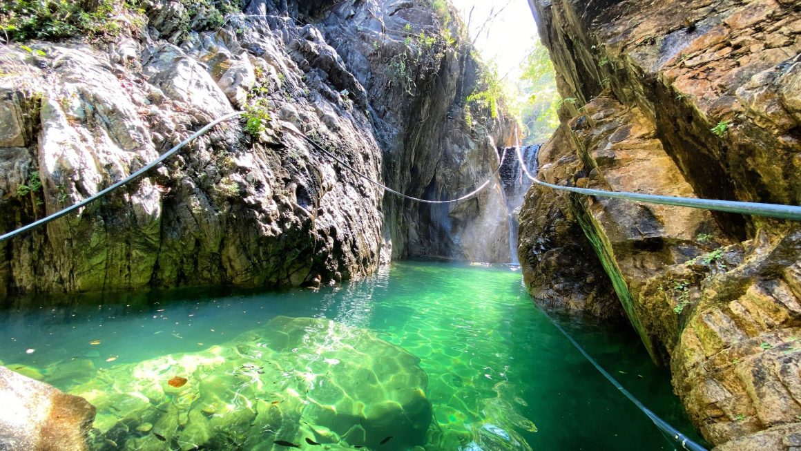
Palo Maria is a beautiful oasis in the Sierra Madre mountains. The trail starts by the bridge and you will see a sign on a fence which says, “cascada” meaning waterfall. Follow the trail up to the mountain, which runs adjacent to the riverbed.
This hike ranges from easy to moderately difficult depending how far you go. If you want an easier hike, you can just hike to the first waterfall, which takes approximately 30 minutes. There are twelve waterfalls in total, and the hike gets more advanced as you continue since the other falls are at a much higher elevation and you will have to crisscross the riverbed multiple times and climb over boulders.
Since you will be walking in the water when you cross the river, we recommend that you wear water shoes or hiking sandals. If you wear hiking shoes, you will either have to keep taking them on and off or hike in wet shoes. We also recommend you bring a trekking pole or you can create a makeshift one from wood you find along the trail.
If you are up for the challenge of a more advanced hike, follow the river all the way up. During your scenic hike, you’ll see birds, butterflies, iguanas, and beautiful rock formations. Along your way up the mountain, you will find several natural pools that are safe to swim in, so bring your bathing suit and enjoy a cooling off break. Expect breathtaking scenery and beautiful waterfalls.
2. Playa Colomitos
Level: moderately difficult
Hiking distance: 2.1 miles roundtrip
Cost: free
How to get there: To get to Playa Colomitos, you will need to take the bus or a taxi to Boca de Tomatlan, which is approximately a 45-minute drive (13 miles) from Villa del Palmar Puerto Vallarta. The bus to Boca de Tomatlan departs from the bus stop on the corner of Constitución and Basillo Badillo street. Once you get to Boca de Tomatlan, you will see a bridge. Cross the bridge and turn right. You will pass through a neighborhood where locals live. The trail isn’t hard to find as there are several signs posted. If in doubt, you can ask directions from the locals. Once you are on the trail, you will see several homemade signs reassuring you that you are going the right direction.
The hike to Playa Colomitos is a combination of hiking through the jungle and along the coast, where you will feel immersed in nature while soaking up the incredible scenery. Playa Colomitos is a secluded beach only accessible by hiking or by water taxi. It should take you approximately 45-minutes to reach the beach depending on how fast you hike and how many rest stops you take. Be sure to bring a bottle of water with you as there won’t be a place to buy water along the way. Once you get there, you will be mesmerized by the powder-soft sand and emerald waters. The water is very tempting to swim in, so we recommend that you wear your swimsuit, as there isn’t a convenient place to change once you arrive. If you plan to spend a few hours at the beach, there are a couple of vendors there that sell drinks and simple snacks like bags of chips. The beach is not shaded, so we recommend that you bring a sun hat.
If you don’t feel like hiking back after spending some time at Colomitos Beach, you can take a water taxi back to Boca de Tomatlan and enjoy lunch or dinner on the beach there before heading back to the resort.
There are many other hikes to be enjoyed in Puerto Vallarta, but these are our favorites. These hikes can be done independently or as part of a guided tour. Ask your Member Services agent or concierge upon arrival about available options.
Villa del Palmar Flamingos
The state of Nayarit, where Villa del Palmar Flamingos is located, is most famous for its beautiful white sand beaches, but it also boasts picturesque hiking trails through the rainforest or along the coastline. Our top choices for hiking in Nayarit are Monkey Mountain and the hike from Sayulita to San Pancho.
1. Monkey Mountain
Level: moderately difficult
Hiking distance: 5.27 miles roundtrip
Cost: free
How to get there: Take a taxi from Villa del Palmar Flamingos to Higuera Blanca. It is approximately a 45-minute drive (20 miles). The trailhead starts on Juan Escutia street.
Monkey Mountain, or “Cerro del Mono” in Spanish, is a mountain that is approximately 1,150 feet high and is a popular hiking route for locals and visitors. This hike gives you the opportunity to explore the incredible jungle landscape while getting in some great exercise. The trail takes you along a well-worn path up to the summit, which guarantees spellbinding 360° views of the whole bay. When you reach the peak, make sure to take a selfie to inspire everyone’s envy. This hike is moderately challenging, so it is only recommended for those who are in good physical condition. Hiking up the mountain is a little exhausting, but when you see the amazing views at the top, the reward will be worth the effort. It is much easier hiking back down the mountain.
The total out-and-back trip time is approximately 4 hours depending on how fast you hike, how many rest stops you take, and how long you choose to stay at the top. There are no shops along the route, so make sure you bring water and a snack with you. Since you are hiking through the jungle, there are plenty of shaded and cooler spots along the trail. Also keep in mind that although its name is Monkey Mountain, you will not see any monkeys along the way. Guided tours and transportation can be arranged through concierge or your Member Services agent.
2. Hike from Sayulita to San Pancho
Level: moderately difficult
Hiking distance: 3.2 miles one way
Cost: free
How to get there: Take a taxi or drive from Villa del Palmar Flamingos to Sayulita. The town of Sayulita is approximately a 45-minute drive (15 miles) from the resort. Once you get to Avenue del Palmer, follow it north until you reach its end. You will see a dirt trail that is not marked, but it’s obvious that it‘s where the trail starts.
Start the day on an adventurous note by taking a hike from Sayulita to San Pancho. The hike should take you approximately 2.5 hours depending on how many breaks you take along the way. There are two options for this hike, either through the jungle or along the beach. We recommend hiking the trail along the beach, where you will pass through some sections of jungle, too. Follow the trail until you get to Playa Malpaso, a beautiful beach where you can enjoy a rest stop. Then continue along the trail until you reach San Pancho. The trail is pretty straightforward. Make sure you bring plenty of water and wear comfortable shoes, not flip-flops. Once you reach San Pancho, reward yourself with a fabulous lunch on the beach. You will find plenty of restaurants dotted along the beach or you can head into the town, where there is also a great variety of restaurants and coffee shops. Once you have refueled, you can take take a taxi or drive back to the resort.
Villa del Palmar Cabo and Villa del Arco
Cabo San Lucas is a top tourist destination that is most well-known for its beautiful beaches, but that’s not all the region offers. It’s also a hiker’s paradise and offers some of the best nature hikes along the coast and through desert and mountain terrain. For those who want to spend time outside exploring its beautiful natural surroundings, here’s a list of the top 2 hikes we recommend and what to expect.
1. Cerró de las Torres
Level: moderately difficult
Hiking distance: 3.2 miles roundtrip
Cost: free
How to get there: Take a taxi or drive from the resort to Via La Paloma street, where the trailhead begins. It takes approximately 13 minutes (4.8 miles) to get there from Villa del Palmar Cabo and Villa del Arco.
Cerró de las Torres is a 3.2 mile hike roundtrip along a desert route that takes approximately an hour and 45 minutes. The level of difficulty is moderate and there is a slight incline as you hike to the summit. You can walk, run, or even mountain bike along the trail. It has some steep sections, but nothing overly strenuous. It’s a wide trail that provides little shade, so we recommend that you go early in the morning or late in the afternoon. Along the way, you will see interesting cacti and seasonal flowers. Once you get to the top, there are great views of the ocean, the Los Cabos Arches, and the whole bay.
2. Santa Rita Hot Springs
Level: moderately difficult
Cost: $180 pesos per person
Hiking distance: Approximately 1 mile roundtrip
How to get there: The Santa Rita Hot Springs are located 62 miles north of Villa del Palmar Cabo and Villa del Arco and it takes approximately an hour and a half to drive there. The hot springs are a short distance from the town of Santiago. The best way to get there is to rent a car and drive there on your own or book a guided tour that includes transportation. Ask your Member Services agent or concierge upon arrival about available tour options.
Baja California is full of natural wonders and there are plenty of hot springs or natural hot tubs that are filled with warm water that comes from deep within the earth and is heated by volcanic activity. The hot springs ”aguas termales” of Santa Rita are located in the Sierra de La Laguna mountain range. On the way there, you will drive down winding dirt roads surrounded by lush vegetation. There is a steep incline and if you decide to drive here on your own, make sure you rent an SUV that can handle the climb. Once you arrive, you will need to pay the entrance fee of $180 pesos (approx. $9 USD) to the attendant and you will be given a wristband to wear. Then you will hike a short distance to the pristine warm water springs where you can enjoy relaxing in the mineral rich waters. Bring supplies with you such as food and beverages or plan to enjoy a full picnic there in the shaded picnic areas. This is a highly recommended day trip to one of Baja California’s most beautiful natural attractions.
Villa La Valencia
There are several great local hikes to do in close proximity to Villa La Valencia that lead up mountains and bring you to lookout points with views of the ocean and Land’s End. Mt. Solmar are Cerro de La Z are two of our favorite hikes just 30 minutes from the resort. Mt. Solmar is the more challenging of the two and is not for the faint of heart. If you are looking for an easier hike, opt for Cerro de La Z. Read more information below.
1. Mt. Solmar
Level: challenging
Cost: $$ for local guide
Hiking distance: 2 miles roundtrip
How to get there: Mt. Solmar is approximately a 25-minute drive (12.7 miles) from Villa La Valencia. Since Mt. Solmar is on private property, there is no public access. However, local guides are permitted access on certain days. Ask your Member Services agent or concierge upon arrival about booking a guided tour.
This trail is marked as challenging since you will hike up a steep elevation 440 feet above Land’s End. This hike is only recommended for those who are in good physical condition. It is a strenuous hike that will give your legs and lungs a workout, but when you reach the viewpoint at the top, the payoff will be huge. It takes around an hour to reach the summit. Make sure you bring plenty of water, a snack, and comfortable hiking shoes.
2. Cerro de La Z
Level: moderately difficult
Cost: free
Hiking distance: 1.3 miles roundtrip
How to get there: Cerro de la Z is a 30-minute drive (13 miles) from Villa La Valencia and the trailhead is easy to find with navigation.
Hill of the Z or ”Cerro de La Z” is a moderately challenging hike that takes you up the mountain to a viewpoint where you can see gorgeous views of Land‘s End and the Pacific Ocean. The hike is 1.3 miles and takes approximately 45 minutes to complete. You can explore this trail independently, but there are also several tour companies that offer guided hikes. Ask your Member Services agent or concierge upon arrival about available options.
Villa del Palmar at the Islands of Loreto
The Islands of Loreto are a paradise-laden oasis that offer many incredible eco-adventures, and hiking is one of them. There are several hikes to do in the area, but our top picks are the Tabor Canyon Trail Hike and Mesquite Canyon.
1. Tabor Canyon Trail Hike
Level: moderately difficult
Cost: free / $$ for expert guide
Hiking distance: 1.6 miles roundtrip
How to get there: It takes approximately 17 minutes (9.5 miles) to get to the Tabor Canyon trailhead by car from Villa del Palmar at the Islands of Loreto.
The Tabor Canyon hike takes you on an incredible climb up the Sierra de la Giganta mountain and the path is along a creek. During some parts, you will have to cross through a riverbed, so we recommend wearing water shoes. The hike also involves bouldering and there are small sections of boulders that you will have to climb over, so bring appropriate footwear, not flip-flops. Continue along the trail, which is well-marked, to Big Rockfall waterfall, a sparkling swimming hole, and be sure to wear your swimsuit so you can enjoy a refreshing dip. The out-and-back trip takes around an hour and a half. You can explore the trail independently or as part of a guided tour. Ask Member Services or concierge upon arrival about available options.
2. Mesquite Canyon
Level: moderately difficult
Cost: free / $$ for expert guide
Hiking distance: 10 miles
How to get there: Mesquite Canyon is a ten-minute drive (3 miles) from Villa del Palmar at the Islands of Loreto. We recommend that you book a guided tour as the trailhead can be difficult to find on your own.
A hike up the Mesquite Canyon, is a moderately difficult but exhilarating hike that takes approximately four hours out-and-back. The trail is through a steep-sided canyon and during the hike you will have to climb over some boulders. You will also have to wade through water that goes up to your waist or even chest, so we recommend wearing water shoes. The trails are full of local flora and fauna and you will have the chance to explore some caves. It’s an absolutely stunning hike with jaw-dropping views of the canyon. The trail is pretty straightforward and well-marked. Be sure to bring plenty of water and some snacks with you.
Villa del Palmar Cancun
Cancun is not a mountainous region, so there aren’t the same level of adrenaline-packed hikes through the mountains as there are in Puerto Vallarta and Los Cabos, but there are still several places where you can enjoy a beautiful walk. We recommend a visit to Kabah Urban Park or a stroll along the Botanical Garden Trail.
1. Kabah Urban Park
Level: easy
Cost: free
Hiking distance: 1.7 miles
How to get there: Kabah Urban Park is approximately a 20-minute drive (8 miles) from Villa del Palmar Cancun.
Kabah Urban Park or ¨Parque Urbano Kabah” is a great place to go for a stroll and get some exercise. This lovely green space right in the heart of Cancun offers a scenic 1.7 mile-long path that loops around the park. It should take you between 45-minutes and an hour to complete the loop. Along the way, you will pass through a jungle area where you can find monkeys. You will also see lush vegetation, Mexican raccoons (coatis), iguanas, birds, and other wildlife. If you would like to do a warm-up workout before your stroll or run through the park, there is a small outdoor gym located at the entrance that is free to use.
2. Botanical Garden Trail
Level: easy
Cost: $120 pesos (approx. $6 USD)
Hiking distance: 1.1 miles roundtrip
How to get there: The Botanical Gardens are in Puerto Morelos, approximately a 50-minute drive (29 miles) from Villa del Palmar Cancun. Ask Member Services or concierge upon arrival about available tour options that include round-trip transportation from the resort.
Enjoy a beautiful stroll through the lush gardens.The official name of the gardens in Spanish is ”El Jardín Botánico Dr. Alfredo Barrera Marín” or the Dr. Alfredo Barrera Marín Botanical Garden. The purpose of the garden is to protect the regional flora and it plays a huge role in the conservation of biodiversity in Quintana Roo. The garden covers an area of 160 acres. The walking loop is just under a mile long and it takes approximately 40 minutes to walk through the gardens where you will see palm trees, tropical plants, cacti, and birds. The opening hours are Monday through Friday from 8:00 am to 4:00 pm.
For all hikes mentioned above, we recommend that you bring a backpack and sunscreen, insect repellant, a sun hat or cap, and a bottle of water. Also remember to wear comfortable clothing and hiking shoes or sandals. Enjoy your time getting closer to nature and exploring all the incredible natural attractions that Mexico has to offer. Happy hiking!


